
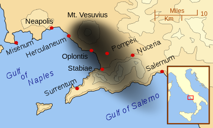
After a week spent traveling around the Bay of Naples, I was still somewhat baffled by what I had seen at Pompeii, Herculaneum, and the Villa di Poppaea Sabina at Oplontis. To visit all these sites I’d ridden the Circumvesuviana, a privately owned train that runs around the base of Mount Vesuvius. At each, the collapsed cone of the volcano loomed over the ruins, but the sites were miles apart. I simply could not wrap my mind around the idea that a single eruption could wreak such devastation in cities so widely scattered. There was only one thing to do – go to the top of the volcano for a birds-eye view.
Though going up to the crater rim became a necessity, I would have made the trip even if I hadn’t needed to better understand the AD 79 eruption. Several days earlier I’d called my Dad to tell him about the Roman ruins I’d been visiting.
“Are you going up to the top of Vesuvius?” he asked unexpectedly. “I flew over that volcano in 1945.”
Dad was a ball turret gunner in a B-17 bomber during World War 2. After the end of the war their plane was converted for aerial mapping of Italy, Germany, and Austria.
“They cut a hole in the floor of our radio shack and mounted a camera over it. We’d turn the camera on, fly straight for a long time, then turn and do the next strip. Back and forth all day long. We were on a training mission in Italy and our route took us near Mount Vesuvius. We weren’t supposed to do this but the pilot said we had a chance to see it and he grabbed the opportunity.”
Vesuvius had erupted just one year earlier and the volcano was a scar on the landscape. “We were flying through really green areas and all of a sudden everything was black, like a burned out area after a fire. We flew all around the edges and the pilot tipped the plane so that everyone could see down into the crater, it was a big smoking hole – black and totally barren.”
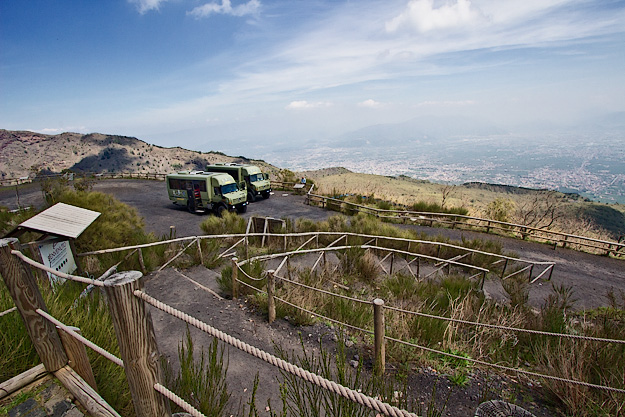
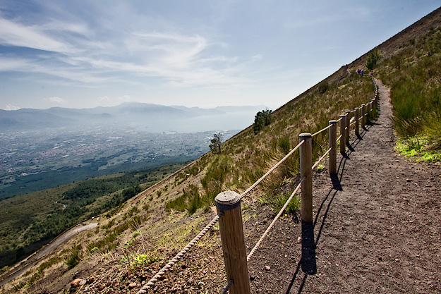
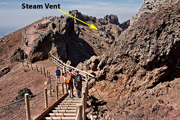
The following morning I hopped aboard one of the BusVia Big Green Buses at the foot of the volcano, for a bumpy ride halfway up the mountain. Where the road ended a narrow trail had been carved into the steep side of the cinder cone. Twenty minutes later, huffing and puffing from the steepness of the climb and the thinner air, I reached the top. Politely but impatiently, I listened to the mandatory presentation by a guide. Finally, I was free to explore the rim path on my own.
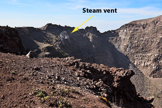
Leaning as far as possible over the wooden guard rail, I peered down into the caldera. The land is no longer black and desolate. Today, the iron rich soil shimmers in shades of pink and red, streaked with gray and spotted with clumps of green where bushes and trees have taken hold. The inner walls of the volcano have slumped, sending loose material tumbling to the bottom like upside-down sand dunes. Here and there, jagged heaps of lava protrude from the rim like giant chimneys.
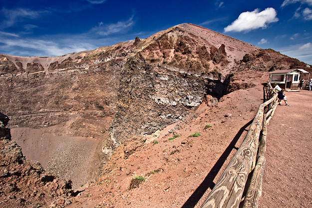
For more than an hour I walked around the cinder cone, feeling a bit nervous whenever puffs of steam rose from vents inside the caldera. Since the eruption in AD 79, Vesuvius has erupted 42 times that we know of, the last event being in 1944. Seventy years ago. I did the math. The average time between eruptions is 46 years. Vesuvius is overdue to blow her top again.
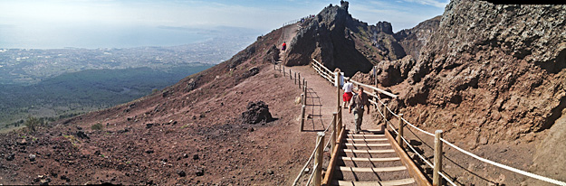
Eventually, I turned my back on the volcano, instead perusing the land that spread some 4,000 feet below me. Through the haze I located Pompeii to the southeast, Oplontis directly south, and Herculaneum to the west. In one direction, a gray tongue of land thrust into the lush green landscape for which Italy is so famous. In another direction, an obvious layer of black ash underlay the vegetation. Evidence of volcanic activity was clearly visible in every direction and I suddenly understood the extent of the devastation in AD 79. But if the effects had been horrific back then, I shudder to think what the next eruption will do. What had been a scattering of small towns is today a dense urban corridor that is home to three million people. Where volcanoes are concerned, the megalopolis that stretches from Naples to Sorrento is the most dangerous place in the world.
How to Tour Mount Vesuvius:
Tours to the top of the volcano are available from the Circumvesuviana train stations in Ercolano (Herculaneum) and Pompeii Scavi. Visitors are taken by regular bus to the foot of the mountain, where they transfer to BusVia’s big green trucks. The official tour is about three hours long, which allows for the bus ride to the foot of the mountain, a 15-minute ride up the mountain to the trail head, a 20-minute steep hike up to the rim, and a short briefing by an official guide, which leaves just a short time to walk the rest of the rim trail before you must head back to catch the return bus. However, if the tours are not completely full, arrangements can be made to take the next bus, which provides more time at the top. Tours leave every hour from 9 a.m. to 3 p.m., and are variously priced, depending on point of departure. I paid 22 Euro (about $30 USD), however I drove directly to the BusVia departure point.
You are a very good writer. Great posts.
Thank you!
That’s quite an adventure, I wanna try it someday.. Great pictures.. love it..
Hope you get to visit this area of Italy someday, Tina. I highly recommend it.
Love your blog! Lots of beautiful and interesting photos and stories!
Thank you SO much, More then Red. It always makes my day when someone says my photos are beautiful AND interesting.
You can imagine, living where I do, that volcanoes fascinate me, though I have an awful lot to learn! This was amazing. I need to go……well, any excuse to visit Italy really!!
That’s the real crux of the matter, isn’t it Linda – ANY excuse to visit Italy 🙂
Can’t modern day scientists,with modern day equipment, more accurately predict when a given volcano is likely to erupt?
Hi Linda: I asked that question when I was at the top. Scientists do monitor the volcano and at the moment the land at the bottom of the caldera is not bulging, so apparently they are not concerned at the moment. But I was told that even a bulge of an inch is cause for concern. It’s just a matter of time, in my opinion.
Living in Sorrento the volcano hovers over the lush verdant landscape. Its ominous presence lingers as you watch it and it watches you. Whenever the earth trembles underfoot, its the first thing I run to look at from the sunny terrace 🙂
Hi Lisa: I’d love to live in Sorrento, despite the looming volcano, but I can imagine how much it must be in the back of your mind.
Not sure I’d want to live in Naples, I guess if you do you tend to put it in the back of your mind and get on with everyday life
I’m inclined to agree, Heather, though I loved Sorrento so much I could definitely live there, and I suspect it’s more directly in the path of future eruptions.
I’m amazed by the volcano’s beauty. It’s something that marked our history and we need to be careful because although this volcano is silent know, you never know when is the next eruption. Very beautiful but also very dangerous!
I agree Marcia. Even scientists say it’s just a matter of time before it happens again.
This looks awesome. So it’s a 20-minute hike up to the top, after the bus ride from the base? Not bad for these views… That’s even cooler that your dad got to see this 70 years ago from a B-17, too!
Hi Jon: Yes, about a 15-20 minute hike. Glad I did it off season, because it would have been schorcing in the summer. However, once at the top, it’s chilly because of the altitude. I love it when my travels connect with something my Dad did 70 years ago!
Mt Vesuvius was great, I loved going there.
Pretty amazing to look down into the crater, huh Zoe?
“…today a dense urban corridor that is home to three million people.”
Why on earth would one person turn a blind eye to history, let alone 3,000,000?
Hi Cosima: Who knows? Why do people live in California along the San Andreas fault or in places that regularly experience Tsunamis? I lived on the Outer Banks of North Carolina for years and houses regularly fell into the ocean when there were Nor’eastes or hurricanes, yet the houses were rebuilt as quickly as they fell down. Makes no sense to me.
Volcanic eruptions can be frightening … hopefully the next one won’t be like 79 AD! Fascinating to look into the depths of destruction though…
Fascinating is the right word, Ian – or maybe frightening would be good too.